Sycamore Canyon Hike
I took Friday off and hiked through Sycamore Canyon, a 16- mile round-trip hike in the Point Mugu State Park in Southern California. It was quite a bit longer than my normal hikes, and I thought I was sore after the hike. As it turns out, that was child's play compared to when I woke up this morning. The link on the photo goes to a (soon-to-be-annotated) Flickr gallery of photos from the hike.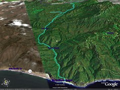
Here's what my Forerunner 201 GPS had to say:
- 17.93 Miles in 5 Hours, 18 Minutes (I took a wrong turn at one point, turning a 16 mile hike into an 18 mile hike)
- Average 140 BPM
- I was in my heart rate zone for 4:40:09 (between 132 and 172 bpm)
- 4908 Kcal (!)
Tags: hike,hiking, SoCal, Thousand Oaks, Ventura County
posted by IvyMike @ 7/31/2005 01:04:00 AM
![]()


0 Comments:
Post a Comment
<< Home